
Thermal Drone Surveys in Texas
The use of drones is increasing rapidly in many industries, everything from roofing and infrastructure inspections, land surveying, spraying crops and search and rescue. Drones have been used in wildlife management for more than a decade. We started using drones to collect data for clients in 2016 and are still finding new uses for them to assist landowners in their management decision making. Texas Parks and Wildlife has recently begun accepting survey data of white-tailed deer collected from thermal drones for MLD compliance.
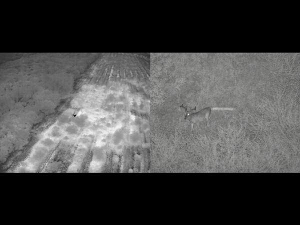
Thermal Drone surveys are conducted similar to a helicopter survey, they both fly parallel lines across a property counting animals, but there are some key differences. Helicopters can cover more ground faster while surveying than a drone, there is no doubt here. Part of this is because the helicopter is much louder and causes animals to move more, making them easier to count as you fly past. The drone typically causes less animal movement, and it must slow or stop to look at every animal as they often times are oblivious or simply stand still and stare, many times from behind a tree or bush. When drone surveys are conducted at night with a thermal sensor, this often times means you count more animals overall as some animals do not run from a helicopter, making them harder or impossible to see. One thing to remember is that “more” doesn’t always mean better data. Just like with a helicopter, you must ensure you are not double counting animals. Transects flown too close together leads to double counting those on the edge of your visibility area. However, done properly, this method can fill a gap that helicopters cannot at times.
The biggest mark that drones have over helicopters is what is mentioned above, the fact that they don’t scare animals as much. This is a huge win for smaller or odd shaped properties, both high and low fenced. While a helicopter flying a low fenced property is not going to permanently scare the deer away from that property, this concern is often enough for landowners to avoid the method entirely. Choosing other survey methods in this case might not work well for a variety of reasons. On a relatively small, high fenced property the concern of injuring animals that run from the helicopter and into a fence is also valid. The use of a drone can solve both of these problems.
Helicopters can typically survey 1000-1200 acres per hour, while a drone can effectively survey 250-500 per hour as a general rule. This variation is based on topography, vegetation height and density, overall animal density, ambient temperature and several other factors. The other main factors in favor of using a drone is reduced cost compared to a helicopter survey, reduced danger as everyone stays on the ground, and a stabilized video file that can be watched by those not present for the survey. While drones are not, and will never be a complete replacement for helicopters in wildlife surveying, they are much needed and very valuable addition in many circumstances.
Posted in: Deer Management, Surveys